Circle Boulevard: Road Diet Pilot & Feedback Form
What is a Road Diet?
A Road Diet is generally described as removing vehicle lanes from a roadway and reallocating the extra space for other uses or travelling modes, such as parking, sidewalks, bicycle lanes, transit, turn lanes, medians or pedestrian refuge islands.
Road Diets have the potential to improve safety, provide operational benefits, and increase the quality of life for all road users. Road Diets can be relatively low cost if planned in conjunction with street reconstruction or resurfacing projects since applying Road Diets consists primarily of changing the pavement markings.
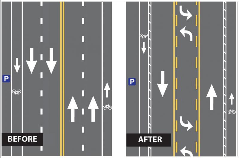
The graphic below shows how the pavement markings change from ‘before’ to ‘after’ a Road Diet is applied.
For additional information about Road Diets, visit the FHWA Office of Safety Road Diets website.
Jump to: Feedback Form
Why Implement a Road Diet on Circle Boulevard at This Time?
Upon completion of the pavement resurfacing project on Circle this summer, a complete re-striping of the roadway will be needed. This provides an opportunity to reallocate the roadway width in such a way that improvements can be made to bicycle and pedestrian facilities. The addition of a continuous center turn lane will improve safety and efficiency for motor vehicles. These improvements are consistent with standards established in the City’s Transportation System Plan, to maintain efficient vehicle movement through the corridor.
Because this is the first Road Diet in Corvallis, we are treating it as a pilot project and hope to learn from the experience, to the benefit of future projects. As a pilot project, its performance will be monitored and measured. The pavement markings will be applied using paint, which can be more easily modified if the pilot shows that changes to the configuration are needed. More on the monitoring of the pilot project can be found below.
What will a Road Diet on Circle Look Like?
Prior to the resurfacing project, which extends from Highland Drive to Dogwood Drive, Circle was striped with four vehicle lanes, substandard bike lanes, and parking in areas where there was room.
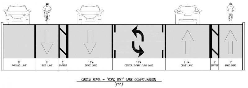
By removing one of the vehicle lanes, and converting another to a continuous left turn lane, we are able to restripe the roadway as shown in the diagram above. This layout includes standard width bike lanes with buffers as called for in the City’s Transportation System Plan. The new layout will make it easier for pedestrians to cross Circle at unsignalized locations because there will be fewer vehicle lanes to cross and a center turn lane that can act as a refuge.
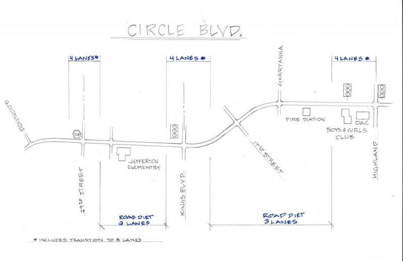
This restriping plan will be applied along the corridor from Highland Drive to Dogwood Drive, except at the intersections of Highland Drive, Kings Boulevard, and 29th Street, where the striping will remain in its original configuration. Because we will not be reducing the number of vehicle lanes at these three intersections, and will be providing a new continuous left turn lane in areas where we do reduce the number of lanes, there should not be any additional delay for vehicles moving through the corridor.
The graphic below clearly identifies where we will maintain the historic four through vehicle lanes, and where we will convert the roadway to two through lanes, plus a center turn lane.

What to Expect?
People traveling on foot can expect:
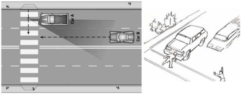
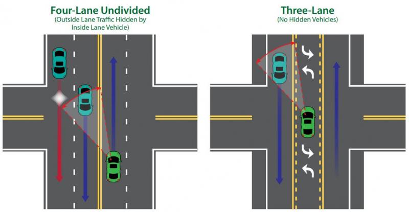
- Elimination of the “multiple threat” type of crash when crossing the street. These type of crashes occur when a car in the near lane stops for a pedestrian, obstructing the line of site between the pedestrian and vehicle in the next lane (see graphic below).
- Slower vehicle speeds, which are important in reducing the severity of crashes if they occur.
- Wider bike lanes and a lower volume center turn lane that can provide refuge from the busier vehicle through lanes when crossing mid-block or at uncontrolled intersections.
- A larger physical buffer between pedestrians on the sidewalks and moving vehicles..
- Upgraded corner ADA ramps to meet current accessibility standards.
- Marked crosswalks on all four legs of the 29th Street intersection.
People traveling by bicycle can expect:
- Wider bike lanes with an additional buffer along the corridor, except at the intersections of Highland, Kings, and 29th, where the original striping layout will remain.
- Slower vehicle speeds, which are important in reducing the severity of crashes if they occur.
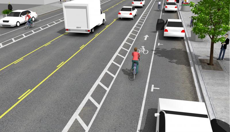
- More room within the bike lane to negotiate around driver doors on parked cars when they are opened, in locations where the bike lane is adjacent to parking (see graphic below).
- An additional level of comfort that encourages cycling by people of all ages and abilities.
People traveling by vehicle can expect:
- A new continuous left turn lane which reduces the potential for rear-end collisions when a vehicle is stopping to make a left turn.
- Improved ability for a vehicle to safely turn onto Circle from a side street with fewer lanes to cross. The new center turn lane can be used as a refuge for one to stop in the lane and merge into traffic, allowing a “two-stage” left turning movement onto Circle.
- Enhanced sight distance of oncoming vehicles when making a left turn from the center turn lane (see graphic below).
- Less speeding with the average vehicle traveling closer to the posted limit.
- Reduction in dangerous maneuvers such as erratic weaving or lane changing at higher speeds.
- No additional time delay to travel through the corridor.
- A need to merge after traveling through the intersections of Highland, Kings, and 29th as the roadway transitions from 4through lanes to 2 through lanes.
Safety Tips for Road Users
Everyone who uses Circle Boulevard should review these simple safety tips to make sure they know how to safely use the new street features.
Tips for Drivers
- Always have an eye out for pedestrians, especially during dark hours or times of low visibility such as when it is raining. Remember, road conditions can impact your stopping ability, so be prepared.
- Be prepared to stop when approaching crosswalks and intersections. Remember, every intersection is a crosswalk in Oregon.
- Slow down in rainy weather and low-light areas.
Tips for Pedestrians
- Be clear to drivers: If you wish to cross the street, be sure to establish eye contact with drivers. If you’re not sure the driver sees you, let the vehicle go first.
- Be visible: Do what you can to be seen. If you’re wearing dark clothing, drivers may not see you. Add a blinking light to your jacket or backpack or carry a flashlight at night. Be extra careful when walking during dusk or early in the morning.
- Cross with caution: Don’t assume the coast is clear just because you’re using the crosswalk and the WALK sign is on. Continue to watch for traffic as you cross the street---especially for turning vehicles.
How are We Monitoring the Road Diet Pilot?
As a pilot project, the performance of the roadway will be monitored and measured. The criteria we will use to evaluate the pilot project are:
- The speed that vehicles travel on Circle
- The number of vehicles, bicyclists, and pedestrians using Circle
- The volume of vehicle traffic on selected neighborhood streets along Circle
- The delay in travel time for vehicles at Intersections
- The response time for Fire Department vehicles leaving the station on Circle
- The number and type of vehicle, bicycle and pedestrian crashes
- Corvallis Transit System (CTS) operations based on its published schedule
- The feedback from the community
These criteria will be used to determine if the lane reduction is operating satisfactorily or if modifications should be considered. Acceptable limits for any of the items to be monitored have not been pre-determined. Positive and negative impacts for each will need to be considered in terms of their magnitude, and weighed against the cumulative impacts for all of the listed criteria.
Monitoring of the corridor’s performance will begin immediately. We will be in regular contact with the Fire Department to determine if response times are being impacted, and the Police Department for a prompt review of reported accidents. CTS route schedules will also be reviewed from the onset for any effects. We will monitor community input as an early indicator of events or patterns that we may want to investigate, and periodically reach out to two of the larger generators of traffic on the corridor, the Boys and Girls Club and School District, to collect their observations.
The review of the remaining criteria is going to rely on newly collected data from traffic patterns that emerge after the lane reduction has been in operation for a period of time. We will collect the “after” volume and speed counts on Circle Boulevard, volume counts on neighborhood streets, and perform intersection analysis in the spring of 2021, once traffic patterns in the area return to a stable pattern. It is possible that if traffic patterns have not returned to something close to pre-pandemic levels, and the system appears to be operating in an acceptable fashion, the pilot project could be extended and measurements retaken when traffic volumes return to something closer to historic levels.
For more information on criteria being used to review performance, please review these materials from past meetings and public engagement opportunities.
- Staff Report on road diet feasibility to the Bicycle and Pedestrian Advisory Board (03/12/20)
- Detailed Road Diet Striping Plan, Attachment A to the staff report
- Corvallis Area Metropolitan Planning Organization report on Circle Boulevard Road Diet Considerations (02/28/20),Attachment B to the staff report
- Circle Road Diet Layout Diagram (04/20/20)
- Criteria to be used to evaluate restriping performance
- December 2, 2019 City Council Meeting
- April 20, 2020 City Council Meeting
We Value Your Feedback
With this new, first-of-its-kind Road Diet in Corvallis, we understand that you have questions and comments—and we’re here to talk to you about them. Submitting your comment provides us with beneficial community feedback. Our Circle Boulevard Road Diet Project Team is ready to hear how the corridor is performing for your daily travel.